


Files
Download Map (752 KB)
Document Type
StillImage
Description
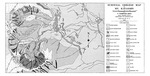
Maine Geological Survey, Open-File Map 76-12. Black and white map showing moraines, talus, avalanche areas, and other surficial features of the area around Mt. Katahdin.
Publication Code
76-12
Publication Date
1-1-1976
Publisher
Maine Geological Survey
Location
Piscataquis County
Map Type
Surficial Geology Regional Maps; Surficial Geology Reports
Map Scale
1:12000
Recommended Citation
Davis, P. Thompson, 1976, Surficial geologic map of Mt. Katahdin: Maine Geological Survey, Open-File Map 76-12, 16" x 32" map, scale 1:12,000. Maine Geological Survey Maps. 1178. http://digitalmaine.com/mgs_maps/1178
Rights Statement

No Copyright - United States. URI: http://rightsstatements.org/vocab/NoC-US/1.0/
The organization that has made the Item available believes that the Item is in the Public Domain under the laws of the United States, but a determination was not made as to its copyright status under the copyright laws of other countries. The Item may not be in the Public Domain under the laws of other countries. Please refer to the organization that has made the Item available for more information.