


Preview
Contributing Institution
Maine Geological Survey
Document Type
Image
Identifier
11578
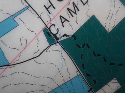
Description
Shows detail of road crossing, stream crossing, and access across private field from new parking lot north of Gillette Road. Blue lines indicate conservation easement across field. For map Legend, see photo HNB_1803.JPG
Project Name: Bald Mountain, Camden
Exact Creation Date
12-16-2019
Location
Camden
Supplemental Rights
Credit must be given to the photographer and the Maine Geological Survey when this photo is displayed, reproduced, distributed and/or used in derivative works.
Keywords
Camden; trail map; Bald Mountain; land management; conservation easement