


Preview
Contributing Institution
Maine Geological Survey
Document Type
Image
Identifier
10117
Description
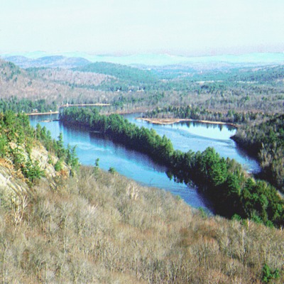
Figure 5: Esker cutting across Kezar Five Ponds, Waterford. The ridge consists of sand and gravel deposited by meltwater flowing in a tunnel beneath glacial ice.
Project Name: Surficial Geology Map Default Photos
Location
Waterford
Supplemental Rights
Credit must be given to the photographer and the Maine Geological Survey when this photo is displayed, reproduced, distributed and/or used in derivative works.
Keywords
esker; glacial; sand; gravel