


Preview
Contributing Institution
Maine Geological Survey
Document Type
Image
Identifier
5886
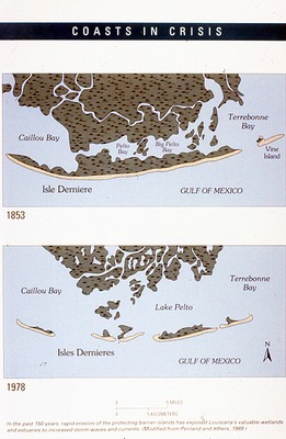
Description
Coasts in Crisis Figure - In the past 150 years, rapid erosion of the protecting barrier islands has exposed Louisiana's valubale wetlands and estuaries to increased storm waves and currents.
Supplemental Rights
Credit must be given to the photographer and the Maine Geological Survey when this photo is displayed, reproduced, distributed and/or used in derivative works.
Keywords
charts; graphs; data; GIS; figure; erosion; coasts; crisis; barrier islands; Louisiana; Terrebonne Bay; Caillou bay; Vine Island; Pelto Bay; Lake Pelto; Isles Dernieres