


Preview
Contributing Institution
Maine Geological Survey
Document Type
Image
Identifier
91177
Description
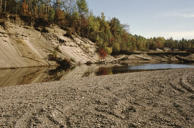
Thick deposits of glacial outwash sand are eroded by the Sandy River. 1-4: The high, stratified sand bank is on the east shore of the river. Cobbles form the sand bank/bar on the west shore. 5: Tom Weddle (MGS) examines meander channel cut into galcial outwash. 6-7: sample location on east bank where woody debris yielded 2120 carbon date.
Project Name: Marvinney Historical Photos
Broad Creation Date
October 2001
Location
Farmington
Supplemental Rights
Credit must be given to the photographer and the Maine Geological Survey when this photo is displayed, reproduced, distributed and/or used in derivative works.
Keywords
Sandy River; erosion; glacial outwash; meander channel; carbon date