


Preview
Contributing Institution
Maine Geological Survey
Document Type
Image
Identifier
90992
Description
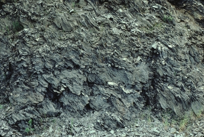
Broken sandstone beds of the Frontenac Formation in the upper plate of a thurst fault zone at the international border on Route 201. Note prominent sub-horizontal bed near bottom of image. The second image is from the same large road cut and shows steeply dipping beddding and a fold toward the right side. Bedding is highly distrupted by faulting. Note that much of this roadcut was destroyed by subsequent improvements at the border crossing.
Project Name: Marvinney Historical Photos
Broad Creation Date
August, 1981
Supplemental Rights
Credit must be given to the photographer and the Maine Geological Survey when this photo is displayed, reproduced, distributed and/or used in derivative works.
Keywords
thrust fault; Frontenac Formation; Silurian