


Preview
Contributing Institution
Maine Geological Survey
Document Type
Image
Identifier
72116
Description
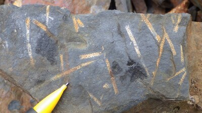
Photo 2: Graptolitic black slate of the Blind Brook Formation (Obb) showing Climacograptus spiniferus, Orthograpus amplexicaulis, etc.
Project Name: STATEMAP Chase Lake Bedrock24k
Location
T10 R10 WELS
Supplemental Rights
Credit must be given to the photographer and the Maine Geological Survey when this photo is displayed, reproduced, distributed and/or used in derivative works.
Keywords
bedrock mapping; outcrop; STATEMAP; Chase Lake