


Preview
Contributing Institution
Maine Geological Survey
Document Type
Image
Identifier
71758
Description
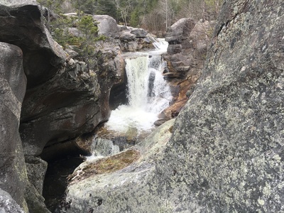
Screw Auger Falls is a bedrock gorge occupied by the Bear River that was created when pressurized, sediment-laden glacial meltwater scoured out and englarged bedrock fractures at the end of the last Ice Age.
Project Name: STATEMAP Old Speck Surficial
Exact Creation Date
5-6-2020
Location
Grafton Twp
Supplemental Rights
Credit must be given to the photographer and the Maine Geological Survey when this photo is displayed, reproduced, distributed and/or used in derivative works.
Keywords
STATEMAP; surficial geology; mapping; waterfall; Old Speck Mountain quadrangle; Grafton Notch State Park; Screw Auger Falls