


Preview
Contributing Institution
Maine Geological Survey
Document Type
Image
Identifier
71570
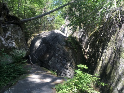
Description
Moose Cave is not a true cave - it is a blocked area of a bedrock gorge (occupied by the Bear River) that came to be when a large slab of bedrock (photo center) fell from the valley wall and became wedged in the gorge.
Project Name: STATEMAP Old Speck Surficial
Exact Creation Date
6-25-2021
Location
Grafton Twp
Supplemental Rights
Credit must be given to the photographer and the Maine Geological Survey when this photo is displayed, reproduced, distributed and/or used in derivative works.
Keywords
STATEMAP; surficial geology; mapping; Old Speck Mountain quadrangle; Grafton Notch State Park; Moose Cave