


Preview
Contributing Institution
Maine Geological Survey
Document Type
Image
Identifier
70950
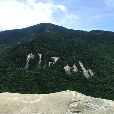
Description
Southwest view of landslide scars (known as “The Slabs” to local climbers) on the flank of Old Speck Mountain from Table Rock. Thin surficial deposits and bedrock structure make this area prone to landslides, with the most recent occurring in 1927.
Project Name: STATEMAP Old Speck Surficial
Exact Creation Date
6-26-2021
Location
Grafton Twp
Supplemental Rights
Credit must be given to the photographer and the Maine Geological Survey when this photo is displayed, reproduced, distributed and/or used in derivative works.
Keywords
STATEMAP; surficial geology; Old Speck Mountain quadrangle; landslide; Old Speck Mountain; Table Rock; Grafton Notch State Park; The Slabs