


Preview
Contributing Institution
Maine Geological Survey
Document Type
Image
Identifier
70500
Description
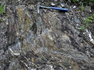
Figure 30. Southeast Boundary fault in the Greenfield quadrangle. A-B (southwest edge of quadrangle) A: Disrupted Greenfield member mudstone and siltstone; B: Greenfield member phyllonite and breccia showing possible dextral shear.
Project Name: Bedrock Geology 24k Greenfield
Location
Greenfield Twp
Supplemental Rights
Credit must be given to the photographer and the Maine Geological Survey when this photo is displayed, reproduced, distributed and/or used in derivative works.
Keywords
bedrock mapping; Greenfield quadrangle