


Preview
Contributing Institution
Maine Geological Survey
Document Type
Image
Identifier
70493
Description
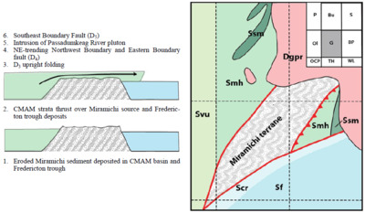
Figure 27. Evolution of east-vergent D2 thrusting. Inset identifies 7½' quadrangles. (Left) Sequence of events leading to current relationships; (Right) Simplified map showing relationships of Miramichi Greenfield segment and adjacent cover rocks. Units: Dgpr-Passadumkeag River pluton; Smh-Mayflower Hill; Ssm – Smyrna Mills; Svu-Vassalboro Group, undifferentiated; Scr-County Road; Sf-Flume Ridge. Quadrangle Index: P-Passadumkeag; Bu-Burlington; S-Saponac; Ol-Olamon; G-Greenfield; BP-Brandy Pond; OCP-Otter Chain Ponds; TH-The Horseback; WL-West Lake.
Project Name: Bedrock Geology 24k Greenfield
Supplemental Rights
Credit must be given to the photographer and the Maine Geological Survey when this photo is displayed, reproduced, distributed and/or used in derivative works.
Keywords
bedrock mapping; Greenfield quadrangle