


Preview
Contributing Institution
Maine Geological Survey
Document Type
Image
Identifier
70486
Description
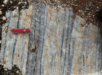
Figure 24. Vassalboro Group (undifferentiated) soft-sediment deformation features. (A) Internal disruption of sandstone components of graded beds (Olamon quadrangle south of Fir Road). (B) Disrupted sandstone and mudstone at base of thick sandstone bed. (C) Small-scale soft-sediment folds (sandwiched between unfolded layers; Olamon quadrangle south of Fir Road). (D) Tectonic fold deforming a broad meso-scale soft-sediment fold (Olamon quadrangle south of Fir Road).
Project Name: Bedrock Geology 24k Greenfield
Supplemental Rights
Credit must be given to the photographer and the Maine Geological Survey when this photo is displayed, reproduced, distributed and/or used in derivative works.
Keywords
bedrock mapping; Greenfield quadrangle