


Preview
Contributing Institution
Maine Geological Survey
Document Type
Image
Identifier
70436
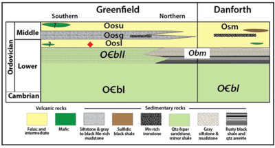
Description
Figure 5. Maine Miramichi stratigraphy and lithologies. Italics indicate units with detrital zircon data. Red diamond= U-Pb ages. Formations: O1bl =Baskahegan Lake, O1bll=Lazy Ledges Road member; Obm=Bowers Mountain; Osm=Stetson Mountain; Oos=Olamon Stream: upper (Oosu), lower (Oosl), and Greenfield (Oosg) members.
Project Name: Bedrock Geology 24k Greenfield
Supplemental Rights
Credit must be given to the photographer and the Maine Geological Survey when this photo is displayed, reproduced, distributed and/or used in derivative works.
Keywords
bedrock mapping; Greenfield quadrangle