


Preview
Contributing Institution
Maine Geological Survey
Document Type
Image
Identifier
70432
Description
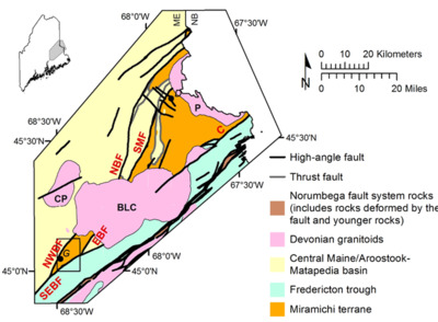
Figure 1. Lithostratigraphic setting of the Greenfield quadrangle (black rectangle) (modified after Osberg et al., 1985). D=Danforth; G=Greenfield. Faults: NWBF: Northwest Boundary; SEBF: Southeast Boundary; EBF: East Boundary; NBF: North Bancroft; SMF: Stetson Mountain. Norumbega fault system: C-Codyville; W-Waite; K-Kellyland). Plutons: P-Pokiok; BLC-Bottle Lake Complex; CP-Center Pond
Project Name: Bedrock Geology 24k Greenfield
Supplemental Rights
Credit must be given to the photographer and the Maine Geological Survey when this photo is displayed, reproduced, distributed and/or used in derivative works.
Keywords
bedrock mapping; Greenfield quadrangle