


Preview
Contributing Institution
Maine Geological Survey
Document Type
Image
Identifier
70139
Description
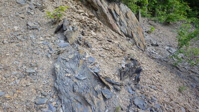
Photo 5: The reverse-fault scarp (Round Mountain fault) between the lower slate member of the Rowe Lake Formation (Orlls; left/west) and the Chase Brook Formation (Ocb; right/east). Viewer facing north.
Project Name: STATEMAP Big Machias Lake Bedrock24k
Exact Creation Date
6-9-2018
Location
T12 R8 WELS
Supplemental Rights
Credit must be given to the photographer and the Maine Geological Survey when this photo is displayed, reproduced, distributed and/or used in derivative works.
Keywords
bedrock mapping; outcrop; STATEMAP