


Preview
Contributing Institution
Maine Geological Survey
Document Type
Image
Identifier
70137
Description
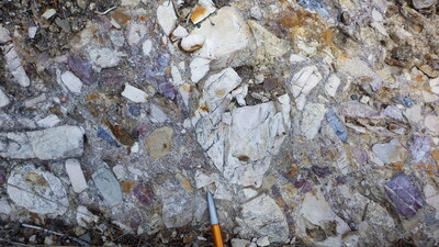
Photo 3: Poorly sorted, polymictic, purplish-red tuff and red jasper pebble bearing conglomerate member of the Seboomook Group (Dsc).
Project Name: STATEMAP Big Machias Lake Bedrock24k
Exact Creation Date
7-7-2020
Location
T12 R9 WELS
Supplemental Rights
Credit must be given to the photographer and the Maine Geological Survey when this photo is displayed, reproduced, distributed and/or used in derivative works.
Keywords
bedrock mapping; outcrop; STATEMAP