


Preview
Contributing Institution
Maine Geological Survey
Document Type
Image
Identifier
67581
Description
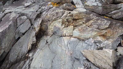
NOTE: The geologic history preserved at this spot is critical to understanding the regional geology. Great care should be taken to preserve and protect it from damage. MAP CAPTION- Photo 12: Unconformity between gray rocks of the Simonton Corners Formation (C#sc) to the left and beneath the older green and thinly laminated rocks of the Goose River Formation (Zgr) above and to the right (southeast). The pencil rests along the unconformity at the top edge of the photo. The unconformity surface is folded in a complex pattern, with the older rocks now above the younger ones, indicating that it is essentially inverted at this location. Eastern shore of Rockport Harbor, about 200 feet south of Photo 11.
Project Name: Camden Quadrangle Bedrock
Exact Creation Date
6-13-2019
Location
Rockport
Supplemental Rights
Credit must be given to the photographer and the Maine Geological Survey when this photo is displayed, reproduced, distributed and/or used in derivative works.
Keywords
Camden; bedrock geology; unconformity