


Preview
Contributing Institution
Maine Geological Survey
Document Type
Image
Identifier
67566
Description
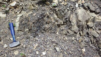
Photo 10: Near vertical graywacke and pyritic black slate of the Ferguson Brook Formation (Ofb), next to Ferguson Brook fault (left).
Project Name: STATEMAP Carr Pond Bedrock24k
Exact Creation Date
6-3-2020
Supplemental Rights
Credit must be given to the photographer and the Maine Geological Survey when this photo is displayed, reproduced, distributed and/or used in derivative works.
Keywords
bedrock mapping; outcrop; STATEMAP; Carr Pond