


Preview
Contributing Institution
Maine Geological Survey
Document Type
Image
Identifier
2977
Description
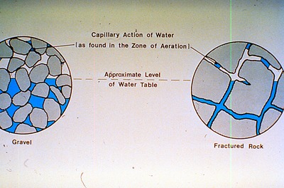
(As found in the Zone of Aeration) - The figure also denotes the approximate level of water table and differences between gravel and fractured rock.
Supplemental Rights
Credit must be given to the photographer and the Maine Geological Survey when this photo is displayed, reproduced, distributed and/or used in derivative works.
Keywords
education; outreach; CREST; figure; capillary action; water table; fractured rock; gravel