


Preview
Contributing Institution
Maine Geological Survey
Document Type
Image
Identifier
21421
Description
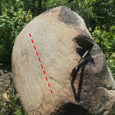
This boulder was moved a short distance to its current location by logging road construction, but it was first transported here thousands of years ago by glacial ice that likely moved it several miles. As the boulder was dragged along in the base of the glacier, friction with other rock debris planed it flat and left striations (grooves) shown in this photo (same trend as red dashed line).
Project Name: STATEMAP Ellis Pond Surficial
Location
Roxbury
Supplemental Rights
Credit must be given to the photographer and the Maine Geological Survey when this photo is displayed, reproduced, distributed and/or used in derivative works.
Keywords
striated boulder; Ellis Pond Surficial Geology Figure 2