


Preview
Contributing Institution
Maine Geological Survey
Document Type
Image
Identifier
58366
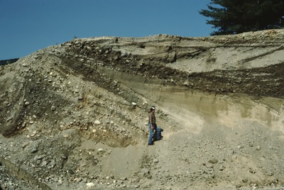
Description
Bethel-NE-88-90. Esker (L) buried by lacustrine and fluvial sediments; pit at jct. of US Rte. 2 w/ Rte. 26, Newry; view to NW. See field notes. Thompson, W. B., 2003, Surficial geology of the Bethel 7.5-minute quadrangle, Oxford County, Maine: Augusta, Maine Geological Survey, Open-File Report 03-45, 14 p. (map published separately as OF Map 03-44).
Project Name: Thompson NGGDPP Grant 2020
Exact Creation Date
7-1-1984
Supplemental Rights
Credit must be given to the photographer and the Maine Geological Survey when this photo is displayed, reproduced, distributed and/or used in derivative works.
Keywords
Bear River; esker; alluvial fan; glaciolacustrine sediments; Chadbourne Pit; Newry