


Preview
Contributing Institution
Maine Geological Survey
Document Type
Image
Identifier
58233
Description
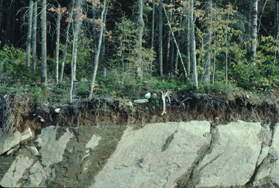
Road cut on E side of Rte. 17 near "Height of Land" scenic viewpoint, Township D (shows thin till over glaciated bedrock). Approximate location.
Project Name: Thompson NGGDPP Grant 2020
Exact Creation Date
9-1-1989
Location
Township D
Supplemental Rights
Credit must be given to the photographer and the Maine Geological Survey when this photo is displayed, reproduced, distributed and/or used in derivative works.
Keywords
thin drift; Township D