


Preview
Contributing Institution
Maine Geological Survey
Document Type
Image
Identifier
55096
Description
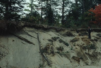
Morrill-WC-80-22. Glaciomarine delta NW of N. Searsmont, ME (Montville Delta). Station 1, where elev. of presumed topset/foreset contact was measured by altimeter (the "topsets" were later recognized as younger stream gravel). View to E, with Bob Johnston
Project Name: Thompson NGGDPP Grant 2020
Exact Creation Date
10-1-1980
Location
Montville
Supplemental Rights
Credit must be given to the photographer and the Maine Geological Survey when this photo is displayed, reproduced, distributed and/or used in derivative works.
Keywords
glaciomarine delta; Montville Delta; Montville; Robert Johnston