


Preview
Contributing Institution
Maine Geological Survey
Document Type
Image
Identifier
54989
Description
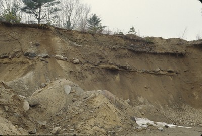
North Berwick-EC-86-18. Boulder lag marking marine erosion surface. Wells town pit, Merriland Ridge, Wells, ME. View to W.
Project Name: Thompson NGGDPP Grant 2020
Exact Creation Date
2-26-2002
Location
Wells
Supplemental Rights
Credit must be given to the photographer and the Maine Geological Survey when this photo is displayed, reproduced, distributed and/or used in derivative works.
Keywords
marine nearshore sediments; Merriland Ridge; Wells