


Preview
Contributing Institution
Maine Geological Survey
Document Type
Image
Identifier
54920
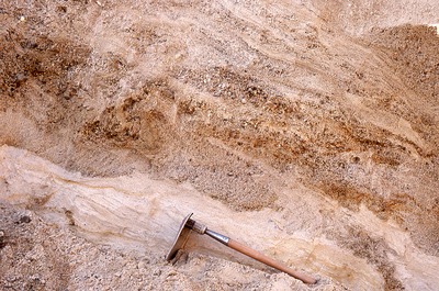
Description
Portland West-NW-85-66. Folded + sheared sand and gravel (shoved from R to L) in Level 2 section, Toppi Pit, Westbrook, ME. View to WSW.
Project Name: Thompson NGGDPP Grant 2020
Exact Creation Date
11-20-1992
Location
Westbrook
Supplemental Rights
Credit must be given to the photographer and the Maine Geological Survey when this photo is displayed, reproduced, distributed and/or used in derivative works.
Keywords
moraines; glaciotectonic structure; Toppi Pit; Westbrook