


Preview
Contributing Institution
Maine Geological Survey
Document Type
Image
Identifier
10290
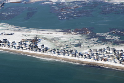
Description
Aerial image of beach, dune, development, marsh, and flooding along Webhannet River during 2019 King Tide. Note that the predicted tide in Portland, ME was 11.7 ft MLLW. Observed water levels only reached 10.6 ft MLLW due to set-down from strong NW winds.
Project Name: King Tides 2019
Exact Creation Date
1-22-2019
Location
Wells
Supplemental Rights
Credit must be given to the photographer, LightHawk, Surfrider Foundation, and the Maine Geological Survey when this photo is displayed, reproduced, distributed and/or used in derivative works.
Keywords
King Tide; highest annual tide; high tide; nuisance flooding; beaches; dunes; marshes; wetlands; seawalls; sea level rise; LightHawk; Surfrider; #lighthawk; #kingtide; #ourfuturesea