

Preview
Contributing Institution
Maine State Archives
Document Type
Image
Identifier
4-212510-I006
Description
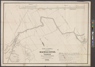
A plan and level of a section of the Machias River. Includes mills, toll bridges, meeting houses, customs house, gaol, school, court house, and graveyard.
Scale 1 inch to 32 rods. 160 rods= half mile.
Exact Creation Date
8-1835
Language
English
Location
Washington County; Machias; Machiasport; Whiting; Lubec; Whitneyville
Other Location
Machias River; Daniel Hill's Brook; Monson's Riplins; Great Eddy; Middle River
Keywords
Cartography; Maps; Surveys