

Preview
Contributing Institution
Maine State Archives
Document Type
StillImage
Identifier
4-212510-I005
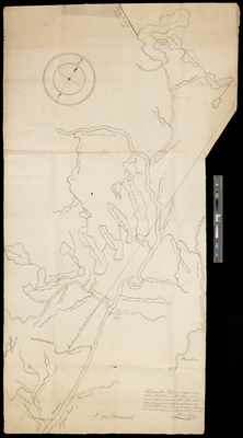
Description
Plan of the St. John River to Quebec and Chaleur Bay in the Gaspe Peninsula. Includes Tobique River, Long Lake (with island), Cross Lake, Square Lake, Eagle Lake, St. Croix Lake, and Portage Lake. Includes indigenous names of geographical features.
Broad Creation Date
ca. 1822
Language
English; Abenaki
Location
Aroostook County; Houlton; Presque Isle; Oxford County; Woodstock
Other Location
New Brunswick, Canada; Gaspe Peninsula; Quebec; Meduxnekeag River; Penobscot River; Mattawamkeag River
Keywords
Cartography; Maps; Surveys