• Home
  • Search
  • Browse State Agencies
  • My Account
  • About
  • DC Network Digital Commons Network™
Skip to main content
Digital Maine Maine State Library
  • Home
  • About
  • FAQs
  • My Account

Home > StateDocs > ACF > Maine Geological Survey > ATLAS_PLATES

Atlas of Plates

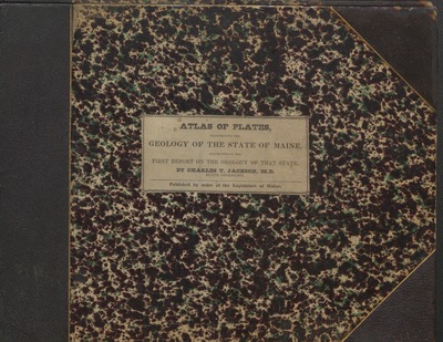
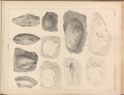
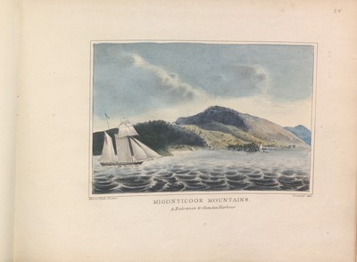
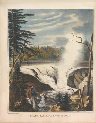
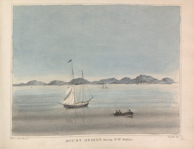
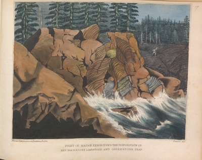
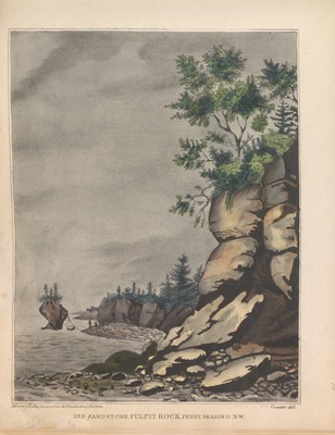
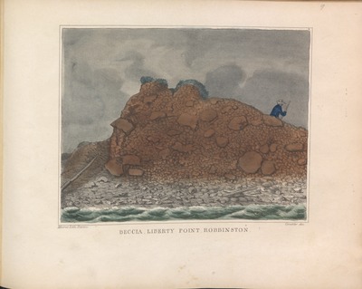
In 1837 the Maine Legislature commissioned a survey of Maine Geology. The report was completed by Charles T. Jackson, MD. There were two parts: the text and the illustrations which are found here.
Printing is not supported at the primary Gallery Thumbnail page. Please first navigate to a specific Image before printing.

Follow

Switch View to List View Slideshow
 
  • Breccia Liberty Point Robbington by Charles T. Jackson, Del Graeton, Maine Geological Survey, and Maine Legislature

    Breccia Liberty Point Robbington

  • Brecciated Green Marble and Red Sandstone Point of Maine Machias by Charles T. Jackson, Del Graeton, Maine Geological Survey, and Maine Legislature

    Brecciated Green Marble and Red Sandstone Point of Maine Machias

  • Cape Rosier Talcose and Micacious Slate by Charles T. Jackson, Del Graeton, Maine Geological Survey, and Maine Legislature

    Cape Rosier Talcose and Micacious Slate

  • Cover of Atlas of Plates Illustrating the Geology of the State of Maine by Charles T. Jackson, Del Graeton, Maine Geological Survey, and Maine Legislature

    Cover of Atlas of Plates Illustrating the Geology of the State of Maine

  • Disposition of Slate and Greenstone Trap-rocks West Quoddy Head by Charles T. Jackson, Del Graeton, Maine Geological Survey, and Maine Legislature

    Disposition of Slate and Greenstone Trap-rocks West Quoddy Head

  • Grand Falls of the River St. John by Charles T. Jackson, Del Graeton, Maine Geological Survey, and Maine Legislature

    Grand Falls of the River St. John

  • Granite Mountains in Mt Desert caleld the Bubies by Charles T. Jackson, Del Graeton, Maine Geological Survey, and Maine Legislature

    Granite Mountains in Mt Desert caleld the Bubies

  • Greenstone Trap-Dyke Intersecting the Porphyry at Yellow Head 1 off Buck's Harbour by Charles T. Jackson, Del Graeton, Maine Geological Survey, and Maine Legislature

    Greenstone Trap-Dyke Intersecting the Porphyry at Yellow Head 1 off Buck's Harbour

  • Greenstone Trap Old Friar's Head Campobello Bearing East Oct. 1st 1836 by Charles T. Jackson, Del Graeton, Maine Geological Survey, and Maine Legislature

    Greenstone Trap Old Friar's Head Campobello Bearing East Oct. 1st 1836

  • Grey-Scale Images of Eleven Mullosks by Charles T. Jackson, Del Graeton, Maine Geological Survey, and Maine Legislature

    Grey-Scale Images of Eleven Mullosks

  • Grey-Scale Images of Twelve Mullosks by Charles T. Jackson, Del Graeton, Maine Geological Survey, and Maine Legislature

    Grey-Scale Images of Twelve Mullosks

  • Grey-Scale Images of Twenty-eight Mullosks by Charles T. Jackson, Del Graeton, Maine Geological Survey, and Maine Legislature

    Grey-Scale Images of Twenty-eight Mullosks

  • Limestone with Fossil Shells' Impression. Head of the Thoroughfare Lubec Aug. 15 1836 by Charles T. Jackson, Del Graeton, Maine Geological Survey, and Maine Legislature

    Limestone with Fossil Shells' Impression. Head of the Thoroughfare Lubec Aug. 15 1836

  • Migonticook Mountaisn and the Entrance to Camden Harbour by Charles T. Jackson, Del Graeton, Maine Geological Survey, and Maine Legislature

    Migonticook Mountaisn and the Entrance to Camden Harbour

  • Mount Ktaadn from W. Butterfield's Oct 8th 1836 Near Grand Schoodic Lake by Charles T. Jackson, Del Graeton, Maine Geological Survey, and Maine Legislature

    Mount Ktaadn from W. Butterfield's Oct 8th 1836 Near Grand Schoodic Lake

  • Mt. Desert Bearing N. W. 10 miles by Charles T. Jackson, Del Graeton, Maine Geological Survey, and Maine Legislature

    Mt. Desert Bearing N. W. 10 miles

  • Point of Maine Exhibiting the Disposition of Red Sandstone Limestone and Greenstone Trap by Charles T. Jackson, Del Graeton, Maine Geological Survey, and Maine Legislature

    Point of Maine Exhibiting the Disposition of Red Sandstone Limestone and Greenstone Trap

  • Printer's Imprint in Atlas of Plates Illustrating the Geology of the State of Maine by Charles T. Jackson, Del Graeton, Maine Geological Survey, and Maine Legislature

    Printer's Imprint in Atlas of Plates Illustrating the Geology of the State of Maine

  • Pulpit Rock Near Perry cove Lewis Maine. View from the East Augutst 10 1836 by Charles T. Jackson, Del Graeton, Maine Geological Survey, and Maine Legislature

    Pulpit Rock Near Perry cove Lewis Maine. View from the East Augutst 10 1836

  • Red Sandstone Pulpit Rock Perry Bearing NW by Charles T. Jackson, Del Graeton, Maine Geological Survey, and Maine Legislature

    Red Sandstone Pulpit Rock Perry Bearing NW

  • Trap-Dyke in New Red Sandstone Friendship's Folly Island Near L'tang N.B. by Charles T. Jackson, Del Graeton, Maine Geological Survey, and Maine Legislature

    Trap-Dyke in New Red Sandstone Friendship's Folly Island Near L'tang N.B.

  • Varigated Marble, Red Sandstone and Trap Rocks Starbirds Creek near Machias by Charles T. Jackson, Del Graeton, Maine Geological Survey, and Maine Legislature

    Varigated Marble, Red Sandstone and Trap Rocks Starbirds Creek near Machias

  • View down St. Croix River with the Devil's Head from Above the Ledge by Charles T. Jackson, Del Graeton, Maine Geological Survey, and Maine Legislature

    View down St. Croix River with the Devil's Head from Above the Ledge

  • View of Camden and the Kennebec Bay from the Migonticook by Charles T. Jackson, Del Graeton, Maine Geological Survey, and Maine Legislature

    View of Camden and the Kennebec Bay from the Migonticook

  • View of Lubec and Campo-Bello from Eastport ME by Charles T. Jackson, Del Graeton, Maine Geological Survey, and Maine Legislature

    View of Lubec and Campo-Bello from Eastport ME

  • West Quoddy Head Lighthouse by Charles T. Jackson, Del Graeton, Maine Geological Survey, and Maine Legislature

    West Quoddy Head Lighthouse


Search

Advanced Search

  • Notify me via email or RSS

Browse

  • State Agencies
  • Subjects
  • Contributors

For Agency Contributors

  • FAQs

Featured Links

  • Maine Government
  • Maine State Library
  • Maine State Agencies
  • Digital Maine Partners

Gallery Locations

  • View gallery on map
  • View gallery in Google Earth
 
Elsevier - Digital Commons

Home | About | FAQ | My Account | Accessibility Statement

Privacy Copyright