

Preview
Contributing Institution
Maine State Archives
Document Type
Image
Identifier
65-207967-I005
Description
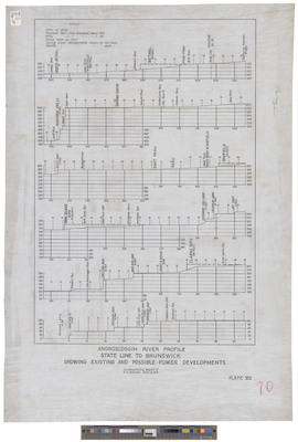
Androscoggin River Profile, State Line to Brunswick Showing Existing and Possible Power Developments. Approximately 28 x 20 inches.
Exact Creation Date
9-14-1918
Dimensions
51 x 71 cm
Language
English
Location
Androscoggin County
Other Location
Clarks Rips, Maine; Ram Island Rips, Maine