


Title
Ice Houses on the Kennebec
Files
Download Full Text
Document Type
MovingImage
Contributing Institution
David Chase
Exact Creation Date
Winter 1-2018
Language
English
Location
Augusta; Chelsea; Farmingdale; Gardiner; Hallowell; Pittston; Randolph; Richmond
Disciplines
Entrepreneurial and Small Business Operations | United States History | Vocational Education
Recommended Citation
"Ice Houses on the Kennebec" (2018). Whitefield Archives. 25.
https://digitalmaine.com/whitefield_books/25
Rights Statement

No Copyright - United States. URI: http://rightsstatements.org/vocab/NoC-US/1.0/
The organization that has made the Item available believes that the Item is in the Public Domain under the laws of the United States, but a determination was not made as to its copyright status under the copyright laws of other countries. The Item may not be in the Public Domain under the laws of other countries. Please refer to the organization that has made the Item available for more information.
Description
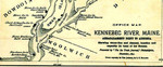
Here is an animated version of a map of Abbagadassett Point to Augusta that shows waterline and channel, location and capacity (in tons) of ice houses along the Kennebec River.
The map was published in the Ice Trade Journal, 1891.