

Preview
Contributing Institution
Scarborough Historical Society
Document Type
Image
Identifier
Encapsulated Collection #28 - Roads and taxes - 10 Nov 1890
Description
A document providing the location of the line between Scarborough and cape Elizabeth.
TRANSCRIPTION
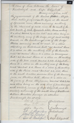
Return of lines between the towns of Scarborough and Cape Elizabeth.
Having complied with the requirements of the revised statutes - Chapter three - Section forty-one, we begin at the mouth of Spurwink River, thence northerly to a stone “marked by an iron bolt.” Said stone being in the northerly wing of the bridge [???] said westerly branch on the Scarborough side of the bridge thence running north 41° West, to a stone standing on Waterhouse Hill “not marked” thence to a stone on the Northerly side of the Larrabee road, “not marked” then to a stone on Wornagans Hill “not marked” thence to a stone on the northerly side of the Saco Roads marked S.1839-C. Elizabeth, then to a stone on the southerly side of the Mussy Road “marked” S, thence to a stone by the northerly side of the Paine road marked “S.C, 1839 thence to the southwestern division line of the cummings farm on Skillins Hill, thence to a stone on the form of Moses Chapmen, “marked” C.W.S. 1870 said stone being on the sideline of Scarborough north westerly corner of Cape Elizabeth, and the westerly extremity of the south line of Westbrook.
William Moulton surveyor in attendance
Scarborough Nov 10th, 1890
L. Plummer } Selectmen
George B Thurston} of
John Moulton } Scarborough
M.J. Peebbles } Selectmen
James H Hartford } of
Geo. [?] Mountfort } Cape Elizabeth
Recorded in Book 1 of Roads and Town Lines Page 30
Return of the line between the Towns of Scarborough and Cape Elizabeth.
Scarborough Historical Society Encapsulated Collection #28.
Transcription by Betty McKown, Scarborough Historical Society.
Exact Creation Date
11-1890
Location
Cape Elizabeth; Scarborough; Cumberland County
Keywords
Town Lines, Roads