

Preview
Contributing Institution
Scarborough Historical Society
Document Type
Image
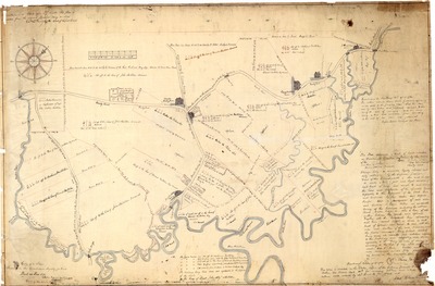
Description
Survey map Moses Bank made of the Scarborough Marshland and property lines nearby in 1784. He had surveyed the land which would now be between Nonesuch and Scarborough Rivers. Because Route 1 did not exist at that time, his survey went as far north as the present-day Payne Road. He presented it to Judge Southgate for approval. This survey was so well done that it later was put on the Registry of Deeds of Cumberland County once Maine became an independent state in 1820. It was helpful to the landowners who had property near the marsh. It clearly showed them whether or not their land included marshland. This survey, nearly 80 years later, was used to help the owners of the various dike companies to know the location and owners of the various lots. 1850-1870
Exact Creation Date
1784
Location
Cumberland County; Scarborough
Keywords
Map, Marshland