

Preview
Contributing Institution
Scarborough Historical Society
Document Type
Image
Description
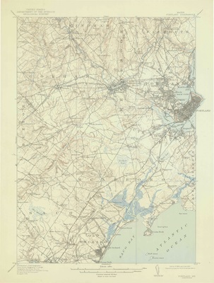
This is the 1943 reprint of the 1916 USGS Map of the Portland Quadrangle - 70° 15′ to 70° 30′W and 43° 30′ to 43° 30′N. The map includes all of Portland and Scarboro (Scarborough) and much of Westbrook, South Portland, Old Orchard, Saco and parts of Windham, Gorham, Buxton, and Cape Elizabeth. This map is of particular interest as it shows the locations of the various railroad lines in 1916 including the various electric rails, such as the "Portland and Saco Electric," various schools, such as the "Broad Turn School," and places of interest such as the "Buggy Meeting House."
Exact Creation Date
1916
Dimensions
20" x 15"
Location
Cumberland County; Scarborough; Portland