

Preview
Document Type
StillImage
Contributing Institution
Maine State Archives
Identifier
209714
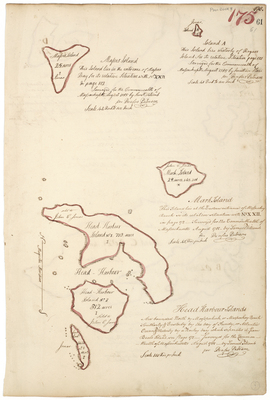
Description
Survey of Mason's Island, Mark Island, and Head Harbour Islands on a scale of 100 rods to an inch. Includes Island A westerly of Rogue's Island.
Exact Creation Date
8-1785
Language
English
Location
Washington County; Jonesport
Other Location
Bay of Fundy; Mooseabec Reach
Keywords
Cartography; Maps; Maine Land Office; Planbooks; Surveys