

Preview
Document Type
StillImage
Contributing Institution
Maine State Archives
Identifier
208369
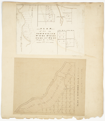
Description
Map #1 is a survey of T13 R6 (Portage Lake), T4 R4 (Island Falls), T4 R5 (Crystal), and T10 R5 in 1861.
Map #2 is a survey of Township G Range 1 WELS in 1859,
Broad Creation Date
1859-1861
Language
English
Location
Aroostook County; Portage Lake; Island Falls; Crystal; Hamlin
Keywords
Cartography; Maps; Maine Land Office; Planbooks; Surveys