

Preview
Document Type
StillImage
Contributing Institution
Maine State Archives
Identifier
208384
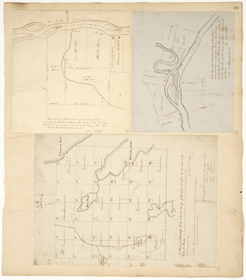
Description
Plan showing the situation of two lots of land numbered 21 & 22 in Township No. 17 in the 8th Range WELS (1845)
A Plan of Township No. 3 in the 13th Range of Townships West from the East Line of the State of Maine (1831)
Survey of two lots of land No. 3 & 5 in Township No. 16 in the 10th range near the mouth of the Allagash (1847)
Language
English
Location
Aroostook County; Allagash
Keywords
Cartography; Maps; Maine Land Office; Planbooks; Surveys