

Preview
Document Type
StillImage
Contributing Institution
Maine State Archives
Identifier
290561
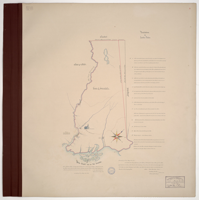
Description
Survey of the town of Arundel, now Kennebunkport, on a scale of 200 rods to an inch. Includes grist and saw mills, meeting house, and tide mills. Copied from Massachusetts Archives Maps and Plans #1394.
Exact Creation Date
5-1795
Language
English
Location
York County; Kennebunkport
Other Location
Badsons River; Goffs River; Folly Island; Green Island; Vawns Island; Bunkin Island; Bass Island; Stage Island; Huff's Cove
Keywords
Cartography; Maps; Maine Land Office; Planbooks; Surveys
Image Location
Rights Statement
No Copyright - United States. URI: http://rightsstatements.org/vocab/NoC-US/1.0/
The organization that has made the Item available believes that the Item is in the Public Domain under the laws of the United States, but a determination was not made as to its copyright status under the copyright laws of other countries. The Item may not be in the Public Domain under the laws of other countries. Please refer to the organization that has made the Item available for more information.