

Preview
Document Type
StillImage
Contributing Institution
Maine State Archives
Identifier
208257
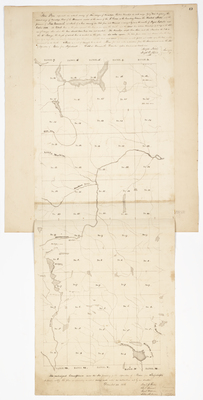
Description
Survey of five ranges of townships, thirteen townships in each range, west of the Monument Line erected at the source of the St. Croix River as the boundary between the United States and the Province of New Brunswick.
Includes Townships 4-16 in Ranges 3-7.
Exact Creation Date
12-28-1826
Language
English
Other Location
Mattawamkeag River; Skittacoos River; Machias River; Aroostook River; Seboeis River
Keywords
Cartography; Maps; Maine Land Office; Planbooks; Surveys
Image Location
Rights Statement
No Copyright - United States. URI: http://rightsstatements.org/vocab/NoC-US/1.0/
The organization that has made the Item available believes that the Item is in the Public Domain under the laws of the United States, but a determination was not made as to its copyright status under the copyright laws of other countries. The Item may not be in the Public Domain under the laws of other countries. Please refer to the organization that has made the Item available for more information.