

Preview
Document Type
StillImage
Contributing Institution
Maine State Archives
Identifier
208228
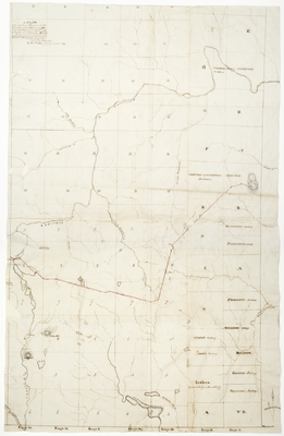
Description
A plan of an exploring line run by the Land Agents of Massachusetts and of Maine in the months of October and November A.D.1828.
Exact Creation Date
11-1828
Language
English
Location
Aroostook County; Mars Hill; Bridgewater
Other Location
Aroostook River; Plymouth; Presque Isle River; Seboeis Lake; Chase Mountain; Sugarloaf Mountain; Penobscot River; Mattawamkeag Lake; Mattawamkeag River
Keywords
Cartography; Maps; Maine Land Office; Planbooks; Surveys
Image Location
Rights Statement
No Copyright - United States. URI: http://rightsstatements.org/vocab/NoC-US/1.0/
The organization that has made the Item available believes that the Item is in the Public Domain under the laws of the United States, but a determination was not made as to its copyright status under the copyright laws of other countries. The Item may not be in the Public Domain under the laws of other countries. Please refer to the organization that has made the Item available for more information.