• Home
  • Search
  • Browse State Agencies
  • My Account
  • About
  • DC Network Digital Commons Network™
Skip to main content
Digital Maine Maine State Library
  • Home
  • About
  • FAQs
  • My Account

Home > StateDocs > sos > ARCHIVES > ARC_IMG > ARC_LAND_OFFICE > PLANBOOK_MAPS > PLANBOOK_17

Plan Book 17

Printing is not supported at the primary Gallery Thumbnail page. Please first navigate to a specific Image before printing.

Follow

Switch View to List View Slideshow
 
  • Page 48. Plan of Township 9 in the 13th Range West from the East Line of the State Showing the location of the Public Lot and the Tract Set out to David Pingree by David Haynes

    Page 48. Plan of Township 9 in the 13th Range West from the East Line of the State Showing the location of the Public Lot and the Tract Set out to David Pingree

  • Page 49. Plan of Township 5 Range 15 West of the East Line of the State in the County of Piscataquis Showing the Location of a public lot set out in the north west quarter of said town.

    Page 49. Plan of Township 5 Range 15 West of the East Line of the State in the County of Piscataquis Showing the Location of a public lot set out in the north west quarter of said town.

  • Page 50.5. Plan of Upton and C Surplus by H. B. Buck

    Page 50.5. Plan of Upton and C Surplus

  • Page 50. Plan of Township 6 Range 14 West from the East Line of the State

    Page 50. Plan of Township 6 Range 14 West from the East Line of the State

  • Page 51.5. Plan of Parkertown flowage, T5 R3 WBKP by A. M. Carter and H. F. Carter

    Page 51.5. Plan of Parkertown flowage, T5 R3 WBKP

  • Page 51. Plan of Dyer Brook Township, 1855 by Abner Weeks

    Page 51. Plan of Dyer Brook Township, 1855

  • Page 52.5. Plan of Public Lots Number 2 and 3, Township 5 Range 4 WBKP (Lynchtown)
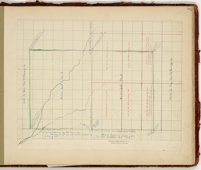
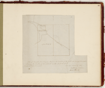
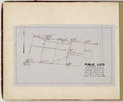
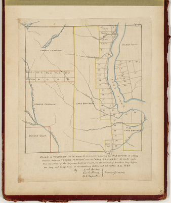
, 1909 by Augustus M. Carter and H. F. Carter

    Page 52.5. Plan of Public Lots Number 2 and 3, Township 5 Range 4 WBKP (Lynchtown), 1909

  • Page 52. Plan of Township 4 Range 8 West of the East Line of the State by Peter Moulton and Zebulon Bradley

    Page 52. Plan of Township 4 Range 8 West of the East Line of the State


Page 8 of 9

  • 3
  • 4
  • 5
  • 6
  • 7
  • 8
  • 9


Search

Advanced Search

  • Notify me via email or RSS

Browse

  • State Agencies
  • Subjects
  • Contributors

For Agency Contributors

  • FAQs

Featured Links

  • Maine Government
  • Maine State Library
  • Maine State Agencies
  • Digital Maine Partners

Gallery Locations

  • View gallery on map
  • View gallery in Google Earth
 
Elsevier - Digital Commons

Home | About | FAQ | My Account | Accessibility Statement

Privacy Copyright