

Preview
Document Type
StillImage
Contributing Institution
Maine State Archives
Identifier
29451
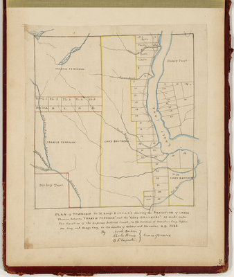
Description
Plan of T16 R7 WELS showing the partition of lands between Francis Ferguson and the Cary Brothers, as made under the direction of the Supreme Judicial Court, on the petition of Theodore Cary, Jefferson Cary, and George Cary.
Exact Creation Date
11-1873
Language
English
Location
Aroostook County; Eagle Lake
Other Location
Birch River; Fish River; Wallagrass Lake
Keywords
Cartography; Maps; Maine Land Office; Planbooks; Surveys