

Preview
Document Type
StillImage
Contributing Institution
Maine State Archives
Identifier
212110
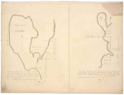
Description
Plan 1: "This Plan represents the survey of a bluff of land situated in River Township Numbered One, principally surrounded by the water of Cold Stream Pond surveyed in March A.D. 1831 pursuant to directions from Daniel Rose, Land Agent, by John Webber. Protracted on a scale of 10 chains to an inch."
Plan 2: "This Plan represents two Gores of land lying East of Cold Stream Pond and the Bluff, West of Half Township No. 1 Range 1 NBPP and North of Township No.1 Old Indian Purchase as surveyed in March A.D. 1834 by Joseph L. Kelsey. Scale of 20 chains to an inch."
Broad Creation Date
1831-1834
Language
English
Location
Penobscot County; Enfield; Lowell
Other Location
Cold Stream Pond; Penobscot River
Keywords
Cartography; Maps; Maine Land Office; Planbooks; Surveys
Image Location
Rights Statement
No Copyright - United States. URI: http://rightsstatements.org/vocab/NoC-US/1.0/
The organization that has made the Item available believes that the Item is in the Public Domain under the laws of the United States, but a determination was not made as to its copyright status under the copyright laws of other countries. The Item may not be in the Public Domain under the laws of other countries. Please refer to the organization that has made the Item available for more information.