

Preview
Document Type
StillImage
Contributing Institution
Maine State Archives
Identifier
211064
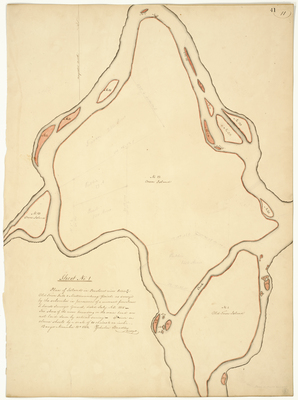
Description
Plan of Islands in Penobscot River Between Old Town Falls and Mattawamkeag Point as surveyed by the subscribers in pursuance of a warrant from Isaac S. Small, Surveyor General, dated July A.D. 1835. The shores of the river bouding on the main land are not laid down by actual survey. Drawn on eleven sheets by a scale of 10 chains to an inch. Penobscot Tribe reserved land for mills, booms, and fisheries marked in red.
Exact Creation Date
7-1835
Language
English
Page 42
Map-Land Office-Planbook 10, p.43 Islands in the Penobscot River between Old Town Falls and Mattawamkeag Point, Zebulon Bradley surveyor, 1835-211064.jpg (24751 kB)
Page 43
Map-Land Office-Planbook 10, p.44 Islands in the Penobscot River between Old Town Falls and Mattawamkeag Point, Zebulon Bradley surveyor, 1835-211064.jpg (24707 kB)
Page 44
Map-Land Office-Planbook 10, p.45 Islands in the Penobscot River between Old Town Falls and Mattawamkeag Point, Zebulon Bradley surveyor, 1835-211064.jpg (23737 kB)
Page 45
Map-Land Office-Planbook 10, p.46 Islands in the Penobscot River between Old Town Falls and Mattawamkeag Point, Zebulon Bradley surveyor, 1835-211064.jpg (23485 kB)
Page 46
Map-Land Office-Planbook 10, p.47 Islands in the Penobscot River between Old Town Falls and Mattawamkeag Point, Zebulon Bradley surveyor, 1835-211064.jpg (21358 kB)
Page 47
Map-Land Office-Planbook 10, p.48 Islands in the Penobscot River between Old Town Falls and Mattawamkeag Point, Zebulon Bradley surveyor, 1835-211064.jpg (23820 kB)
Page 48
Map-Land Office-Planbook 10, p.49 Islands in the Penobscot River between Old Town Falls and Mattawamkeag Point, Zebulon Bradley surveyor, 1835-211064.jpg (24394 kB)
Page 49
Map-Land Office-Planbook 10, p.50 Islands in the Penobscot River between Old Town Falls and Mattawamkeag Point, Zebulon Bradley surveyor, 1835-211064.jpg (23913 kB)
Page 50
Map-Land Office-Planbook 10, p.51 Islands in the Penobscot River between Old Town Falls and Mattawamkeag Point, Zebulon Bradley surveyor, 1835-211064.jpg (23801 kB)
Page 51
Keywords
Cartography; Maps; Maine Land Office; Planbooks; Surveys
Image Location
Rights Statement
No Copyright - United States. URI: http://rightsstatements.org/vocab/NoC-US/1.0/
The organization that has made the Item available believes that the Item is in the Public Domain under the laws of the United States, but a determination was not made as to its copyright status under the copyright laws of other countries. The Item may not be in the Public Domain under the laws of other countries. Please refer to the organization that has made the Item available for more information.