

Preview
Document Type
StillImage
Contributing Institution
Maine State Archives
Identifier
208134
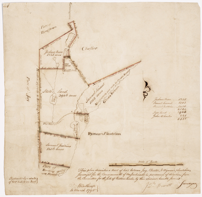
Description
Survey of a tract of land between Jay, Chester, and Wyman's Plantation, now Chesterville area. Scale of 200 rods to 1 inch.
Exact Creation Date
3-1795
Language
English
Location
Franklin County; Chesterville; Farmington; Wyman Twp
Other Location
Tyngtown; Chester; Fayette
Keywords
Cartography; Maps; Maine Land Office; Planbooks; Surveys
Image Location
Rights Statement
No Copyright - United States. URI: http://rightsstatements.org/vocab/NoC-US/1.0/
The organization that has made the Item available believes that the Item is in the Public Domain under the laws of the United States, but a determination was not made as to its copyright status under the copyright laws of other countries. The Item may not be in the Public Domain under the laws of other countries. Please refer to the organization that has made the Item available for more information.