

Preview
Document Type
StillImage
Contributing Institution
Maine State Archives
Identifier
207699
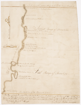
Description
Plan of Kennebec River and islands from the north line of the Plymouth Claim to the south line of the Bingham Million Acres. Includes front and back of page.
Exact Creation Date
1-1798
Language
English
Location
Somerset County; Norridgewock
Other Location
Kennebec River
Keywords
Cartography; Maps; Maine Land Office; Planbooks; Surveys
Image Location
Rights Statement
No Copyright - United States. URI: http://rightsstatements.org/vocab/NoC-US/1.0/
The organization that has made the Item available believes that the Item is in the Public Domain under the laws of the United States, but a determination was not made as to its copyright status under the copyright laws of other countries. The Item may not be in the Public Domain under the laws of other countries. Please refer to the organization that has made the Item available for more information.