

Preview
Document Type
StillImage
Contributing Institution
Maine State Archives
Identifier
299138
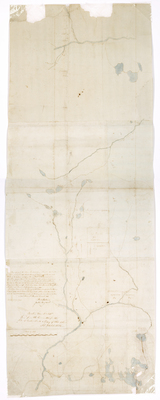
Description
Plan representing the River Penobscott from a Pine Tree marked on the East Side of said river about 3.5 mile southward of Old Lammon Stream and northerly to its source and from thence north to the Canada Line.
Exact Creation Date
2-2-1795
Language
English
Location
Aroostook County; Penobscot County
Other Location
Penobscot River; Mattawamkeag River; Piscataquis River; Howland; Passadumkeag; Mattawamkeag;
Keywords
Cartography; Maps; Maine Land Office; Planbooks; Surveys
Image Location
Rights Statement
No Copyright - United States. URI: http://rightsstatements.org/vocab/NoC-US/1.0/
The organization that has made the Item available believes that the Item is in the Public Domain under the laws of the United States, but a determination was not made as to its copyright status under the copyright laws of other countries. The Item may not be in the Public Domain under the laws of other countries. Please refer to the organization that has made the Item available for more information.