

Preview
Contributing Institution
Maine State Archives
Document Type
StillImage
Identifier
209739
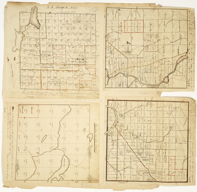
Description
Plan of T5 R6 WELS (Mt. Chase)
Plan of T11 R5 WELS (Ashland)
Plan of T6 R1 NBKP (Holeb)
Plan of TD R1 WELS (Fort Fairfield)
Broad Creation Date
1832-1840
Language
English
Location
Aroostook County; Ashland; Fort Fairfield; Somerset County; Holeb Twp; Penobscot County; Mount Chase
Other Location
Holeb Pond; Aroostook River
Keywords
Cartography; Maps; Maine Land Office; Planbooks; Surveys
Rights Statement
No Copyright - United States. URI: http://rightsstatements.org/vocab/NoC-US/1.0/
The organization that has made the Item available believes that the Item is in the Public Domain under the laws of the United States, but a determination was not made as to its copyright status under the copyright laws of other countries. The Item may not be in the Public Domain under the laws of other countries. Please refer to the organization that has made the Item available for more information.