

Preview
Contributing Institution
Maine State Archives
Document Type
StillImage
Identifier
208423
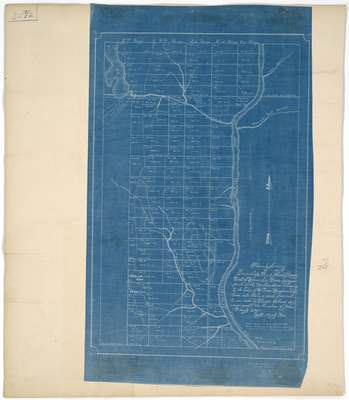
Description
Survey of T1 R3 BKP WKR (now Carrying Place) on a scale of 100 rods to an inch. Retraced as blueprint in 1912 by Frank H. Sterling with note "actual measurement in 1908 shows North line to be 3 miles 37 1/2 rods from Snow & Humphrey's Plan."
Broad Creation Date
1820; 1912
Language
English
Location
Somerset County; Carrying Place Twp
Other Location
Carrying Place Rips; Kennebec River; Pierce Pond
Keywords
Cartography; Maps; Maine Land Office; Planbooks; Surveys
Image Location
Rights Statement
No Copyright - United States. URI: http://rightsstatements.org/vocab/NoC-US/1.0/
The organization that has made the Item available believes that the Item is in the Public Domain under the laws of the United States, but a determination was not made as to its copyright status under the copyright laws of other countries. The Item may not be in the Public Domain under the laws of other countries. Please refer to the organization that has made the Item available for more information.